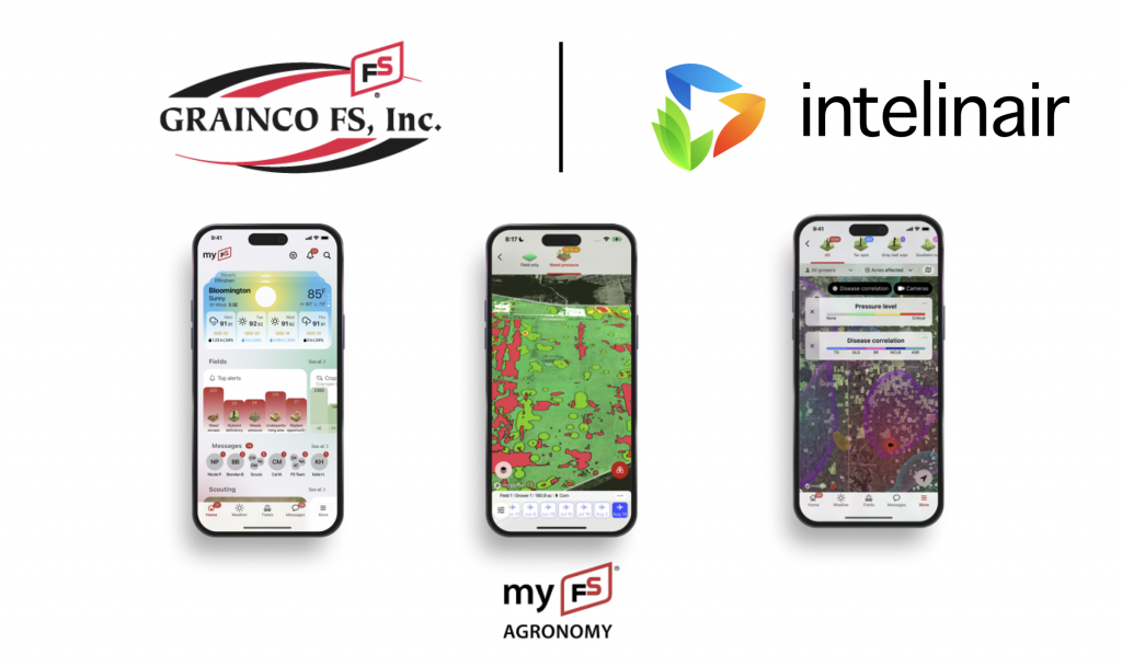
Ottawa, Ill. & Indianapolis (May 14, 2024) – New for the 2024 crop season, GRAINCO FS is offering myFS Agronomy as its latest digital agronomic tool for on-farm data-driven decision-making for its farmer customers in Kendall, LaSalle, and Grundy counties in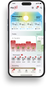 Illinois. The new digital platform and app, developed with Intelinair, provides in-season and postseason actionable insights and analytics for improved operational efficiency and return on investment. For years, GRAINCO FS has been at the forefront of providing innovative digital solutions to its customers. The recently launched app available now brings new features and functionality for an improved experience.
“We embarked on our ag tech journey nearly six years ago, driven by a commitment to leverage technology to generate the best return on investment for our customers,” said Alan Drake, General Manager of GRAINCO FS. “Partnering closely with our farmers, we recognized the immense potential of data-driven decision-making and continue to enhance our program to support their operations. Our strategy remains focused on an ever-evolving omni-channel where our growers can connect anytime and anywhere with all aspects of doing business with GRAINCO FS. We are striving for a seamless experience where growers can monitor the health of their fields, pay off a bill, view an open contract, chat with our team – the list only continues to evolve with what our customers need. As we navigate the challenges posed by fluctuating commodity prices this growing season, tools like myFS Agronomy will focus on decision-making that will maximize returns on every acre.”
GRAINCO FS uses the tech platform to analyze the crop on every acre across their entire trade territory to ensure their crop specialists are given the best data to make the decisions during the season to maximize the crop and to understand what seed, inputs, and practices will bring the highest ROI for each acre and in each situation postseason. All of this being built on real, local data gives their customers access to information they have never been able to see.
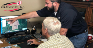 Cal Mason, Farm Data Manager for GRAINCO FS, said, “Our mission is to do what is best for our farmers. Using myFS Agronomy, we are able to take an unbiased approach, find what works and bring this information to our customers. Whether it’s helping them decide whether or not to replant and making sure their fields are clean or helping them select the best seed and where to plant it, we have taken a 360-degree in-season and postseason approach to partnering with our customers.”
Having several years of experience with this technology, GRAINCO FS has found that providing support to help their customers learn and utilize the product is critically important to their success.
“When a grower decides to partner with us, we make sure we are with them every step of the way ensuring they get the most out of the technology. From training them to use myFS Agronomy and interpreting the data, to making sure each field with a problem has boots on the ground so no opportunity is missed, we are there to support them,” said Morgan Picht, Data Management Specialist for GRAINCO FS.
Crop specialists and the data management team members partner with the customer to review and interpret their field data and from there they decide what actions might be taken, if any.
GRAINCO FS Crop Specialist Jason Hamer said, “My customers want to feel exceptionally confident that they are making the best decisions possible. With the analytics, I know how to direct my customers to make the most profitable decisions for their farm. Together, we are able to look at the information and make decisions we both feel great about.
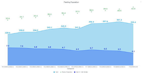
“One of the most eye-opening things that we are taking action on this year is corn planting populations. I always thought 34K to 36K was good enough, and the analysis, across an astronomical amount of acres, did not show that. The information showed we needed to push certain hybrids harder. This is one of the easiest things we can do to increase profitability.
“Looking forward, what makes me most excited is that as more people get on board in our geography, we are creating a community to drive our territory and our yields forward. Each person that joins, builds this data and the community. We all get better because of it,” added Hamer.
“Our long-term vision with our ag tech journey is to partner as consultants with our growers. We strive to be their go-to farm advisor with a committed emphasis on helping determine the best plan for each field. With the information we now have access to, we can customize a field plan based on various factors, including slope, seed, soil type, and many other historical data points,” added Drake. “This allows us to analyze every input to generate the best ROI for every acre. Our digital journey is not one to replace the salesman/grower relationship, either. With the technology at hand, we are working to only enhance our partnerships with our growers to empower them with data analysis to help them make better decisions.”
Conner Schmidt, National Sales Leader for Intelinair, said, “Our goal is to make technology simple enough that anyone can utilize it with analytics that find the answers to two difficult questions – What is the problem and how do I fix it? Analyze is a big step in that direction that this feature will continue to evolve.
“GRAINCO FS has and will continue to play a large role in this innovation. They are a company that relentlessly pursues better solutions for their customers, and they are not afraid to lead the way in uncharted territory. In the early stages of Analyze, they were the first to embrace the information and bring it to their customers. I was able to watch their team use Analyze to consult their growers to make numerous large and impactful decisions last fall which will pay dividends in this challenging market environment. I look forward to working together with GRAINCO FS to push the envelope further,” added Schmidt.
About myFS Agronomy
With the myFS Agronomy platform, farmers and retailers can view fields from anywhere at any time and these features and much more:
- Connect and access many data layers and records on field activity, imagery events, agronomic insights, and scouting reports all season long.
- Review top ag news headlines, GRAINCO FS agronomic information, and CBOT crop contracts.
- View regional and field-level weather insights, including current conditions, rainfall totals, forecasts and interactive radar.
- Digitally connect with the GRAINCO FS team and receive alerts on important information, including field activity, imagery events, and agronomic resources.
- Available on iOS, iPadOS, Android, Android tablet, and also can be accessed through the web.
For more information about the myFS Agronomy platform or to request a demo, visit www.graincofs.com/myfsagronomy.
Images: Find myFS Agronomy platform images here.
About GRAINCO FS, Inc.
GRAINCO FS, Inc. offers advanced farming, crop protection, seed, nutrient management, forages, soil & tissue sampling, precision farming, diesel fuel, lubricants, propane, and turf products at our locations throughout LaSalle, Grundy, and Kendall Counties. As a cooperative, GRAINCO FS, Inc. is a dependable source for quality products and services, provided through skilled professional employees that offer environmentally and economically sound solutions to meet the changing needs of its patrons. Visit graincofs.com or follow us on our social media channels for more information.
About Intelinair
Intelinair provides whole-field insights all season long to farmers and ag retailers through its easy-to-use interactive platform, AGMRI. Through AGMRI Insights and AGMRI Analyze, Intelinair’s proven data analytics capabilities tracks every acre, every factor – emergence & population impacts, nutrient utilization, hybrid and variety performance, and even weather impact – for data-driven in-season and postseason decision making and identifies sustainability opportunities. For more information, visit intelinair.com or follow us on our social media channels.

